King Schools - Review 5
Private Pilot Knowledge Test Course
Airspace Definitions
By Farmboyzim
For some background on what this review is going to be dealing with click HERE.


www.farmboyzimsflightsims.com
FBZFS


As I progress through the King School Private Pilot Knowledge Test Course, I am learning things that make my "simulation" training far more interesting and enjoyable. Jumping into an aircraft in the sim and flying about is easy, but following the rules, is a bit more challenging. Using the simulator and "flying by the book" is an invaluable tool in preparing for my license. I'm putting into "virtual practice" what I am learning about "real world" flying through this course. Truly, if you are into the sim hobby, take it a step further and learn the rules of the skies. Now that's what makes it "as real as it gets", and gives that gray matter some exercise. Speaking of exercising the gray matter and flying by the book, this edition of the King Schools Private Pilot Test Course is going to cover Airspace, and that's not what's between my ears!
As you fly along in the wide open blue, you are responsible for knowing your position, both vertically and geographically, to ensure that you are in compliance with the airspace regulations. These regulations help to ensure safe separation of aircraft, and in the case of VFR pilots, are meant to provide minimum visibility and cloud clearance so that other traffic can be seen in time to take any corrective actions needed to avoid a mishap.
Here's a great memory aid to help you in remembering what the airspaces are and what they represent:
CLASS MEMORY AID USE
A Altitude Controlled
B Big Controlled
C Crowded Controlled
D Dialogue Controlled
E Elsewhere Controlled
G Go For It Uncontrolled
Below is a chart of how these airspace would look viewed from the side.

Letís start at the bottom and work our way up, beginning with Class G Airspace. While flying in Class G Airspace, you are not required to communicate with anyone. This is the only airspace that is uncontrolled. Airspace that is controlled is meant to protect IFR pilots from run in's with VFR pilots. Mostly all Class G Airspace will be found west of the Mississippi. Just about all of the eastern part of the US is controlled air space (See the yellow "G").
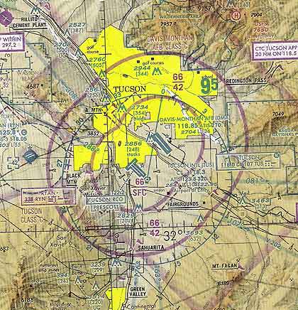
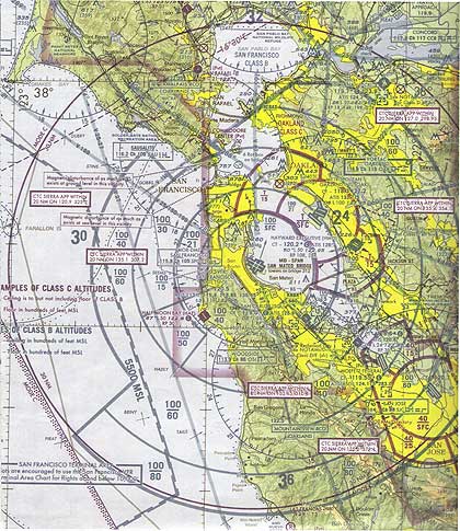
What do these airspaces look like on a chart? I provide an excerpt of a sectional chart from the King School manual for this review, but it is probably best to get yourself a sectional chart, so that you can also refer to it and see the colors
a bit better. I know it looks a bit confusing, but one of the great things about the King Course is that you can just grab the slider bar and "rewind" to a point in the narration that you are not clear on. Personally, I used the rewind in this section a few times! It's like telling the teacher to repeat what they said over again as many times as you like, without getting a nasty "you're wasting my time" look! John King is more than happy to repeat himself for you!
So, if Class G is uncontrolled airspace, the next up on our list would be Class E airspace, and we enter the world of controlled airspace. Class E airspace (yellow "E") extends upward from either the surface or a designated altitude to the overlying or adjacent airspace. Included in this airspace are Federal Airways, air space beginning at either 700 ft AGL or 1200 feet AGL used to transition to or from the terminal or enroute environment, enroute domestic,
and offshore airspace areas designated below 18,000 feet MSL. Unless designated at a lower altitude, Class E airspace begins at 14,500 MSL over the United States, including the airspace overlying the waters within 12 nautical miles of the coast of the 48 contiguous states and Alaska, up to but not including 18,000 feet MSL (17,999 in other words!), and the airspace above FL600 (60,000 feet). So that's Class E airspace! We've only just begun! Don't worry. Just go over it a few times and it will start to make sense. If you can read a road map, you can read a chart and recognize different airspace designations!
Now that I have you all stoked up for more (smile here!), lets move on to Class D airspace. A blue segmented circle on the chart represents Class D airspace (See the yellow "D" in the above figure). The lateral (side to side) dimensions of Class D airspace are based on the instrument procedures for which the controlled airspace is established. Each airport will have its own different lateral dimensions. The vertical dimensions of Class D airspace are normally up to and including 2,500 feet above the particular airport's elevation. If the dimension is different than standard, it will be reflected on the chart with ceiling and floor information.
If the airport has a tower that only operates on a part-time basis, the airspace will only be classified as "D" airspace only during the hours of the towers operation. You must also have two way radio communications for all towered airports in Class D airspace for takeoffs and landings, regardless of the weather. Class D = Dialogue. The only equipment that you're required to have, other than the plane itself, is a VHF transmitter and receiver.
D
G
E
C
Moving up the "Airspace Ladder" we come to Class C Airspace. Remember to think congested or crowded. Class C Airspace is represented by a solid magenta line. The usual vertical limit in Class C airspace is 4,000 feet AGL unless otherwise noted.

Inner Circle
Outer Circle
Solid Magenta Line
The Core Surface Area, also known as the Inner Circle, has a radius of 5 nautical miles. The Inner Circle airspace extends from the surface to 4,000 feet AGL above the primary airport in the area. The Shelf Area, also called the Outer Circle has a radius of 10 nautical miles and extends from 1200 feet AGL to 4,000 feet above the primary airport between the surface area and the Outer Circle. Think "mushroom". Not shown on the chart is an area called the "Outer Area". This area has a radius of 20 nautical miles or 10 nautical miles out from the outer circle. In this area, pilot participation is not required. However, if you plan on entering the Class C airspace, this is the area where you would establish comms with the primary airport. Remember, this must be done prior to entering the Class C airspace. In the figure at left, there happens to be two Class C airports, as is depicted by the solid magenta lines.
When flying into Class C airspace, the minimum equipment that you must have is a two-way radio, a 4096-code transponder, and a Mode C encoding altimeter.
If you happen to be at a satellite airport located within the Class C airspace, you must contact the primary ATC as soon as you can after takeoff.


Magenta
Blue

Class B airspace is indicated with a solid blue line, has various shapes, and there are a few more things that are required of you as a pilot, to be allowed clearance into Class B. In ways, it is similar to Class C. Here is a list of the "Must Have's" for Class B airspace:
- ATC authorization regardless of the weather conditions.
- Private Pilot Certificate or Student Pilot. However, if you are a student pilot, there are additional requirements, such as the Class B airspace must be that of which the student has trained in, certification for solo flight in Class B airspace by the instructor, etc.
- Certificate with the appropriate logbook endorsements
- Two-Way radio communication
- 4096 code Transponder with encoding altimeter.
With some exceptions, all aircraft that are within 30 miles (Mode C Veil or 30 Mile Circle) of a primary Class B airport facility from the surface up to 10,000 MSL must have an operable transponder having either Mode-S or 4096-code capability with Mode C automatic altitude reporting capability. "B" means "Busy", so if you don't meet the requirements of the above list; stay clear of Class B airspace! Various altitudes of the Class C airspace are indicated also, i.e., 100/SFC, 100/40, 100/50, etc.

Solid Blue Lines
Mode C Veil
or 30 Mile Circle
In the 48 contiguous States and most of Alaska, Class A airspace ("A" = Altitude) extends from 18,000 feet MSL up to and including 60,000 feet. This also includes the airspace overlying the waters within 12 NM of the coast of the 48 States and Alaska. Flying at these altitudes it is required that you be instrument rated and your aircraft appropriately equipped. There are no VFR flights allowed up in this neck of the woods!
Whew! I'm going to let this soak in for both you and me. It's not really as confusing as I think I may sound! Get yourself a Sectional Chart and have a good look at it. They all have clear and concise legends on them for your convenience. Think 3 dimensional and mushroom! Sounds like a chant! John King does an outstanding job making this as clear as can be in the King Private Pilot Knowledge Test Course. The graphics that are used in the course were an immense help in "thinking 3D". Being able to go back over the subject matter was very handy for this topic. I might add that taking this course as time allows is another big benefit to this type of course!
We'll rap up Airspace Definitions with Special Use Airspace in the next installment.


Thanks For The Visit !


